Fitzroy Crossing (wikipedia)
is a small town in the Kimberley region of Western Australia, 400 kilometres (250 mi) east of Broome and 300 kilometres (190 mi) west of Halls Creek. It is approximately 2,524 kilometres (1,568 mi) from the state capital of Perth.
It is 114 metres (374 ft) above sea level and is situated on a low rise surrounded by the vast floodplains of the Fitzroy River and its tributary Margaret River. In 2006 the population of the Fitzroy Crossing town-site was approximately 1,500, with a further 2,000 or so people living in up to 50 Aboriginal communities scattered throughout the Fitzroy Valley. About 80% of the Fitzroy Valley population were Indigenous Australians with a split of closer to 60/40 (Aboriginal/settler) in the townsite. Tourism, cattle stations and mining are the main industries in the area.
Pre-European history
Fitzroy Crossing and the lands and valleys around it were the home for a number of Aboriginal language groups. When Fitzroy Crossing was established the main group was the Bunuba People, their land stretching from the present day Brooking Springs and Leopold Downs Station to the Oscar, Napier and King Leopold Ranges. The Bunuba are the River and Hill people.
Another group in the area stretching on the other side of the Fitzroy River from Gogo, Fossil Downs and Louisa Downs Station and on either side of the Margaret River, are the Gooniyandi People. The plains Aboriginal people are the Nyigina and further south are the Walmakarri, the people of the Great Sandy Desert.
Other traditional owners of the area are the Njikena, Konejani and Waladjari peoples.
European history
One of the first European explorers of the Kimberly area was Alexander Forrest and his party in 1879, following the Fitzroy River to its junction with the Margaret River at Geikie George. The party then travelled east as far as Darwin. Following this exploration, around 1882, the first sheep stations were established around the mouth of the Fitzroy and the next couple of years saw the stations move out west with Noonkanbah and Quanbun opening up in 1886.
The area was finally settled in 1886 by Mr McDonald when he set up the Fossil Downs cattle station. This was following a three-year, 3,500 mile trek from Goulburn, New South Wales.
Fitzroy Crossing received its first bridge in 1935; which was built up into a more substantial structure in 1958. However this bridge could be closed for months during the monsoonal summer. In 1974 a new bridge was built 200 meters south of the crossing which moved the focus of the settlement from its original site.
The town was gazetted in 1975, but had been shown on maps since 1903.
Prone to occasional flooding, the town was inundated in 2002 and 2011 following heavy rain events in the region.
Indigenous issues
From 1951 to 1955, S Preston Walker, a missionary with the United Aborigines Mission (UAM) on loan to the Department of Native Affairs, WA, opened up a novel Fitzroy Crossing Feeding Depot-Mission which was handed back to the Junjuwa Community in February 1987. He and other UAM missionaries set up a basic school and a health centre which was later taken over by the WA government and expanded to where it is today (2008).
In February 2008, a Coronial inquest described the living conditions for Aboriginal people in the Fitzroy Crossing area as “a national disaster with no disaster response”. Though the coroner noted a co-ordinated government response to the problems of Fitzroy Crossing to be lacking, local leaders have taken some action. In 2007, a restriction on alcohol sales was campaigned for by members of the indigenous population: early indications suggest the restrictions have been positive for the town. The Rudd Federal government announced in mid-April 2008 that it supported the continuation of the alcohol ban beyond its expiry date of 23 May 2008, citing that the alcohol ban has led to:
- a 50 per cent fall in the number of people seeking treatment at the Fitzroy Crossing Emergency Department.
- a 27 per cent reduction in alcohol-related domestic violence, and
- a 14 per cent increase in high school attendance.
Climate
Fitzroy Crossing has a climate that is in transition between monsoonal and semi arid. The climate is very hot, with the average maximum temperature ranging from 30°C in July to 41°C in November. The highest temperature was recorded on 1 January 1969, when it reached 48°C. The lowest minimum was recorded on 27 June 1971, when the temperature dipped to 0.6°C. Most of the rainfall occurs in between December and March (summer/early autumn). April through to October are dry, although cooler (autumn, winter and early spring).
30th May, Friday
Well, here we are in the bustling metropolis of Fitzroy crossing. (Population – approx. 900). We left Broome at 8 this morning and had a 400km drive to an overnight stop at the Fitzroy river lodge. You are going to say “here she goes again”……… I LOVE THE KIMBERLEYS, this place for me is so spiritual, and just wait until I get to Kununurra, then I really will be mouthing off . The drive was awesome. The Kimberleys at this time of the year is so gorgeous. Everything is green, the billabongs and creeks are full of water, the cattle look good, kangaroos are abundant. We know that we are now finally in the true Kimberleys, Boab trees and giant termite hills take over the landscape. The termite hills are like little cities and I wonder if they have little underground highways so that they can visit each other. We stopped going into town to fuel up. There are dogs wandering around everywhere, they don’t seem to belong to anyone and I wonder who feeds them. It all seems quite sad to me. Fitzroy crossing is a dry town, by that I mean it’s a total alcohol ban. No alcohol sold at all. You can have a drink at the resort in the bar but no takeaway. The problems the Indigenous people have with alcohol is of great concern so the strict licencing laws start happening right from the Pilbarra. Here, in Fitzroy crossing they are at the strictest. They seem to think that it might be helping but we are not sure. We have heard stories of the locals driving to Kununurra, bringing the grog back and selling it. Boys, beware, because here, if you are caught having a pee in the bushes it’s a $1000 fine. I can’t understand why because this is really in the middle of nowhere. The only radio station we can pick up here is Indigenous radio which is not really that good. Thankfully we can pick up the TV, so the Mr. Ralph can watch his football seeing as it’s Friday.
31st May, Saturday
We have decided not to go to Old Halls creek (seeing as we’ve been there, done that before). Ralph said that there are plenty of places still left on our travels to do prospecting. We have just booked into the Bungle Bungle caravan park which is on the way to the Bungle Bungle ranges and Purnululu national park. I will do a tour tomorrow on my own (full day) and Ralphie will stay with Hugo (they did offer to look after Hugo for the day, which was really kind of them but Ralph explained that he had already seen the Bungles before and his foot is still hurting and the tour requires about 7 kms of walking). He saw the Bungle Bungles when we was working at Argyle Diamond mines. This park is very rustic, the cabin stays are tents and the dining area, if you want to use it is a massive tent. The theme here is very African as the place is owned by a South African lady. There are ginormous potjie pots in the camp fire area and fencing is all the African grass theme. We went to the fire area for a pre dinner drink…..not many peeps there, so we had a glass of wine and came back to the van for dinner and a shower. We were offered again, while we were sitting there by a staff member to look after Hugo for the day…..so sweet. We said that I would go on my own and the boys will have a boys day in. This place is really awesome. I will write a good review for them on tripadvisor.
1st June, Sunday
Up early, to another stunning Kimberley morning. I took myself off to the bus outside the office at about 7’ish leaving the 2 boys together to look after each other for the day, watch footy etc. I sat up front of the us with the driver until the first stop, which was the visitors centre. About 1 ½ hours on the 4×4 bus. It was about 30kms and the roads are corrugated and lots of creek crossings so the going was slow. We stopped off at the visitors centre which is the entrance to Purnululu national park, to have a look around, toilet and a rekkie on the rest of the trip. Off we went again, this time with me in the bus to give someone else a chance to sit up front. Our first stop was to visit the Cathedral Gorge. Quite a hike (about 4kms) but well worth the walk. I, of course was the slowest but it wasn’t a competition and the tour operator says to take your walk at your own pace which suited me just fine. I got back, about ½ hour before lunch (which was served as part of the deal). Off, we went again to Echidna chasm. The walk to there was 1km there and 1km back, all along the creek bed and rocks, stones the whole way. It was really hard and made the 4km walk look like a walk in the park. I made it. Last one there and middle of the road back, so not too bad. It was so worth the pain, believe me. I don’t think that the pictures would do it justice. It was a 2 hour drive back to camp and I think that some people fell asleep on the way. There were only 14 of us but the terrain was so magnificent that I just had to keep looking. Got back to camp and back to my poor deglected boys, who were happy to see me. Xxxx. I freshened up to go to dinner because my trip included dinner and then we just paid for Ralphie. It was really nice, just camp food, which is a nice change from the fancy stuff. We were warned by someone that there were cane toads under our van and to watch Hugo. I can’t believe that these horrible little beasts have crossed the border from Queensland to the Territory to here. We got back and the little horrible beasts were hopping around everywhere. We could’nt believe how many there were. Tomorrow we head off for Kununurra, a nice easy little drive, about 200kms…… Easy day. Xxxxxxxx
Bungle Bungle Range is the landform that is the major component of the Purnululu National Park in Western Australia – it is often used as a synonym for the national park area.
The traditional human inhabitants of the area are the Kitja peoples.

-

- Potjie pots at Bungle Bungles

-

- Getting ready for happy hour


-

- Our bus


-

- on the way to Cathedral Gorge


-

- The pictures don’t do this place any justice


-

- Another termite hill


-

- On the way to Picaninni chasm….. it was tough going for me


-

- the entrance to the chasm… you can touch the wall on both sides by spreading your arms


-

- disgusting toad
-

- This is only some of them, they others hopped away and then came back
-

- Turkey creek now Warmun

-

- Hawks sitting at the road house waiting for a hand out
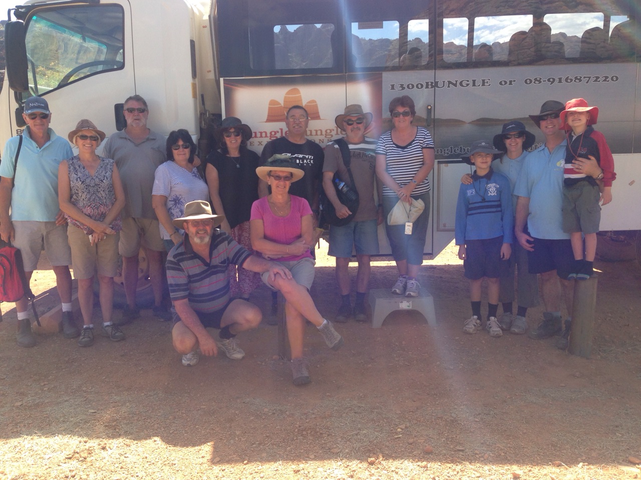
The day tour I went on.
The origin of the landscape
The distinctive beehive-shaped towers are made up of sandstones and conglomerates (rocks composed mainly of pebbles and boulders and cemented together by finer material). These sedimentary formations were deposited into the Ord Basin 375 to 350 million years ago, when active faults were altering the landscape. The combined effects of wind from the Tanami Desert and rainfall over millions of years shaped the domes. Weathering also helped create this marvel. Water seeps into the rock, and at night it expands as it gets colder. This creates small cracks which eventually wears out the rocks.
A 7 km diameter circular topographic feature is clearly visible on satellite images of the Bungle Bungle Range. It is believed that this feature is the eroded remnant of a very ancient meteorite impact crater and is known as the Piccaninny impact structure.
Can picture everything you are writing about – love it!! …keep enjoying your adventure. Much love. Xx
Didn’t stop in Derby for the Barra burger. 😉 xx
You do like natural disasters dont you!!! Earthquakes in Italy and volcano dust across the Kimberley.
We spent a night in Firzroy crossing camping near the resort and had happy hour 2 dollar cans int the bar.
Love
Beryl
Sitting at Bungle Bungle caravan Park, waiting for happy hour. Can’t see any volcano dust just yet. xxxx
Envy you at the Bungles. Arent they wonderful
Beryl
Awesome Beryl x
Wow,,,looks good sista,,,,,,stay safe and look out for flat dogs
Hugo is swimming with the little fresh ones 🙂