-

- Rock formation on the beach

-

- Rock formation on the beach


-

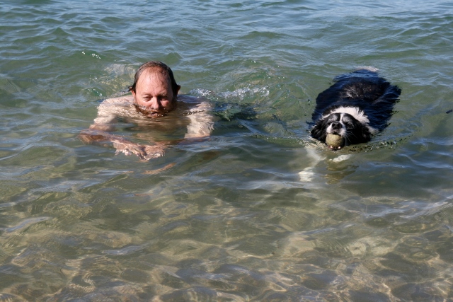
- Ralph and Hugo


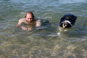
- Ralphie and Hugo
Point Samson is a small coastal settlement 1,579 km north of Perth and 18 km north of Roebourne in the Pilbara region of Western Australia. The town is a popular holiday location for the nearby mining towns, including Wickham, Karratha and Dampier. Fishing is the main industry.
From 1938 to 1966 blue asbestos or crocidolite was carried here by rail from Wittenoom for shiploading by Australian Blue Asbestos Pty. Ltd.
The townsite was investigated for further development in the 1980s
The population of Point Samson was 274 in 2006.
“courtesy of Wikipedia”
Point Samson
19th May, Monday
We left at sparrows, stopped off at Fortesque roadhouse for petrol, a wee stop and to eat our brekkie which I had prepared before we left. We used to get the toasted bacon and egg sarnie on the go but when they are charging you about $30, you have to think twice. So we eat what we have prepared before. We stopped again in Karratha for some groceries to last us until we get to Port Hedland. We got to the Cove Caravan Park at about lunch time, set up and then went to the beach. It is awesome here, so beautiful. The little beach we found is so secluded, not many waves for Hugo and a great swim for us all. We initially booked in for 2 nights but we think that we might stay for 4. The fishing looks great, the weather is awesome, the beaches are divine, what more would you want. Only thing though is the Cove caravan park is expensive, very sterile and very structured. All concrete and stones and the little grass they have put out, no tent pegs…….we were warned. We are across the road from the ablution blocks and there is a camera on the roof that feeds back to the office which is really in our face. So!……. if you want to sit here, pick you nose and flick your snollies all over the place you are going to be caught on Candid Camera by Mrs. Manager in the front office. 🙂
20th May, Tuesday
Booked in for another 2 nights.We took a drive to the old historic town of Cossack and visited the old goal in Roebourne. We bumped into people we knew from Perth in the Goal house… small world. It’s sensational again today, about 34 degs. Not a cloud in the sky and no wind. From the lookout you can see the Port (Cape Lambert) with all the Iron Ore ships waiting out at sea to come in and load. Ralph worked on the electrical side of this port a while they were building it. The mines around here are mostly Iron Ore and big gas plants. Ralphie went fishing, Chicken for dinner. :-). When he got back we went for a swim again. Honestly, this beach is so awesome. We didn’t go in too deep though as a largish shark had been spotted and I made sure that someone else was in deeper than me. :-). We have been bitten stupid by sand flies. We both look like we have the pox and I am sure that we are not the only ones. Another day gone on our travels.
Roebourne History– courtesy of Wikipedia
Roebourne is a former gold rush town in Western Australia‘s Pilbara region. It is 202 km from Port Hedland and 1,563 km from Perth, the state’s capital. It prospered during its gold boom of the late 19th century and was once the largest settlement between Darwin and Perth. At the 2006 census, Roebourne had a population of 857.
Roebourne’s name honours John Septimus Roe, the first Surveyor General of Western Australia.
The Pilbara region was first explored by Francis Thomas Gregory in 1861. He and his exploration party arrived at the head of Nickol Bay, landing near what was to become Roebourne, and travelling about 60 km inland to present day Millstream Station. Gregory regarded the area as highly suitable for pastoral settlement. The first settlers, including Gregory’s cousin Emma Withnell and her young family, arrived in the Roebourne area in 1863. The Withnells established themselves on the banks of the Harding River 13 km from the coast, where they had access to a reasonable fresh water supply, and took up 30,000 acres (120 km²) at the foot of Mount Welcome. In common with many settlers at the time, they hired local Aboriginal people to work on their properties as shepherds, labourers and shearers.
By 1865, the population of the area had grown to about 200, and the Withnells’ property served as a local hub, with John Withnell opening a store and providing cartage services to the other settlers. Prior to the construction of a church in the area, services were held in their home.
The Government Resident, Robert John Sholl (1819–86), arrived in November 1865 from the failed Camden Harbour settlement (near Kuri Bay) to provide assistance in developing the region and set up camp near the Withnells’ home while trying to find a suitable townsite. He eventually decided to locate the town at his camp, and on 17 August 1866, after surveyor Charles Wedge drew a draft plan consisting of 106 lots, Roebourne became the first gazetted town in the North West. It became the region’s administrative centre and various government buildings, shops, services and hotels set up business. Sholl himself served as Justice of the Peace, district registrar and magistrate, and he was concerned with the plight of the local indigenous people and made submissions to the Government to ensure they had basic rights.
In 1872, the town was destroyed by a cyclone. Many of the buildings from shortly after this time are heritage listed. The site of the Withnells’ house, which was rebuilt in 1937 by a later owner, is located on Hampton Street at the foot of Mount Welcome.
Gold from Nullagine, discovered in 1878, and surrounding copper and tin mines contributed to Roebourne’s prosperity in the 1880s and 1890s. With the decline of both, Roebourne lost the majority of its European population and became a shadow of its former self. Remnants from that era of prosperity are various National Trust buildings around the town.
The area was struck by another cyclone in 1925 that destroyed the Port Samson jetty and lifted the bridge to Pope’s nose from the river bed. Several buildings were also destroyed with the towns residents seeking refuge in public brick buildings during the storm. Until the 1960s, Roebourne was a non-indigenous town operating as a regional administrative centre, with strict controls and curfews placed on movement of Aboriginal people to, from and within the town. Most Aboriginals were confined to camps and reserves a few kilometres away. However, as mining companies seeking to exploit the iron ore in the region constructed other company towns such as Dampier and Wickham for their workers, and as pastoralism declined, and with changing attitudes to Aboriginal welfare at governmental level in the late 1960s, Roebourne became a majority Aboriginal town as people moved out of the crowded camps and reserves, and from the outlying stations.
In later years, Roebourne became notorious for the struggles between Aboriginals and police that were documented in a federal report dealing with Aboriginal deaths in custody, which were documented as a major issue in Aboriginal affairs from the 1980s onwards. The report showed that Roebourne (with a largely Aboriginal population of 1,200) had ratios of police to citizens that were five times that of towns in more settled parts of Western Australia.
Present day
Currently Roebourne serves the passing highway traffic and tourism, especially as the gateway to many national parks in the interior. The town’s education needs are met by the Roebourne School (1905), a K-12 school serving about 250 Aboriginal students. Roebourne also contains a TAFE campus, library and telecentre, as well as a small hospital. Many other services are provided from Karratha, 40 km away.
The area is home to the Ngarluma people, but many Yindjibarndi and Banyjima people previously from outlying stations also live in the town.


-

- A warning for Aboriginal people because they are not allowed to mention a dead persons name
Cossack History– courtesy of Wikipedia
Cossack (Historic name : Tsien Tsin) is an historic ghost town located 1,480 km north of Perth and 15 km from Roebourne in the Pilbara region of Western Australia. The nearest town to Cossack is Wickham.
Cossack is located on Butchers Inlet at the mouth of the Harding River. It is reached by a single, sealed road that follows the original causeway across a series of tidal salt flats. The overall landform of the region around Cossack is a low, flat plain with occasional rocky hills and ranges. The vegetation is mainly grass, spinifex and low shrub, with occasional trees (mangroves) along watercourses and in gullies. The mangrove scrub becomes quite dense along the shoreline and at the mouth of the inlet.
The main road from Roebourne to Cossack continues past the town of Wickham and the Cape Lambert iron ore port (operated by Pilbara Iron), and terminates at the fishing town of Point Samson. The townsite is not visible from the main road, and only becomes apparent as the road rounds Nanny Goat Hill.
The site of the former town is defined by Nanny Goat Hill, Tien Tsin Lookout, the hilly ground to the north-east and north-west, and Butchers Inlet to the east and south-east. Past the townsite, the road winds up to the Reader Head Lookout, from which sweeping views of the surrounding coastline can be seen. Many of the buildings are listed by the National Trust.
The erstwhile Tien Tsin Harbour is now known as Port Walcot
Cossack in 1898
In May 1863, Walter Padbury landed his stock at the mouth of the Harding River near the present site of Cossack. Cossack was first known as Tien Tsin Harbour, after the barque that carried Padbury and his party. The ship that brought the state’s Governor, Frederick Weld, in December 1871 was named HMS Cossack and the town adopted this name in 1872. Cossack was the first port in the North West, and was critical to the development of the pastoral industry in the region.
Pearling
In 1866 the town of Roebourne was declared, and the pearling industry began in the region. Cossack was the birthplace of Western Australia’s pearling industry and was the home of the colony’s pearling fleet until the 1880s. Many small boats off the Port Walcott coast dived for pearl shell during the 1860s using Aboriginal labour, including women and children. By early 1869, there were 14 small vessels pearling in the area, with an average crew of three Europeans and six Aboriginals. By the early 1870s up to 80 luggers were operating in the area. The pearling industry also attracted a large Asian population. By 1895, there were 989 Malays and 493 Aboriginals employed on 57 vessels at Cossack. The high number of Asians in the industry, including Japanese and Chinese as well as Malay, led to the establishment of an Asian quarter known as ‘Chinatown’.
In 1881 a cyclone damaged the town, and every pearling vessel then operating either foundered or was beached. In 1885, 44 vessels were operating out of Cossack. In that year a parliamentary select committee recommended the closure of several pearling banks in the area due to depletion. In 1886, the main pearling industry moved to Broome.
Causeway and tramway
During the 1870s, a causeway was built across the tidal salt flats that separate Cossack from the main road. The causeway still forms the only access to the town from land.
A horse-drawn tramway between Roebourne and Cossack was completed in 1887 the same year that the municipality of Cossack was declared, and the north-west gold rush commenced.
Heritage buildings
The main stone buildings were constructed in the 1880s. Administrative and other public buildings built there in the 1890s continued a style adopted by the emerging state; these have been surveyed by state heritage groups and determined to be architecturally and historically significant.
Decline of the township
Following the move of the pearling industry to Broome and the decline of the gold rush, the population of Cossack dwindled. The harbour proved unsuitable for the larger ships of the early 20th century. Between 1902 and 1904, a jetty was constructed at the nearby hamlet of Point Samson. In 1910, the port moved there and the municipality of Cossack was dissolved. In 1913 a leprosarium was established on the other side of the river, moving to Darwin in 1930. Wool bales and pearls would be loaded on to a lighter for transport to ships 3 miles off shore which would take the cargo to England. Inhabitants of the town in the early twentieth century included Greeks and other Europeans, Japanese, Malays, Timorese, Koepangers and Aru Islanders. The town was abandoned in the 1950s.
The region is subject to violent storms and cyclones and was severely damaged at different times in its history. Its use as a port for the profitable pearling industry and other economic booms saw investment and backing from Perth and it remained an important northern port. The town was abandoned after the 1940s, leaving substantial stone buildings in a state of disrepair. The state government established a survey, in 2007, into the potential for restoration or revitalisation of this remote town.
Cossack cemetery
Cossack contains a small cemetery comprising separate European and Japanese precincts. The pearling industry of the 19th century was notably dangerous, with many pearlers losing their lives. Those buried in the Japanese cemetery were mainly divers and others involved with the pearling industry; others, including many Aborigines, were lost at sea. The first interment in the cemetery is believed to have taken place in 1869, when a man died while walking to Port Walcott in January and was buried there.
At least 41 Europeans and seven Japanese were buried there, with the last interment recorded in 1915. Those buried there include William Shakespeare Hall.


21st and 22 May Wednesday and Thursday
Wednesday we didn’t do much, went for a walk, swimming etc. No site seeing. I found a therapist that might help me with my neck so went for an 1 1/2 hour session. Not sure if it’s worked yet. Will let you know at a later date. We went fishing today at the causeway and we have dinner. Hallaluah. 🙂 . We have met a lovely Swiss couple from Lucerne (Sp?) Gregory and Thereza. They are travelling around Oz for a year and they have bought a little camper. They are such lovely people. Gregory has just recently retired and Theraza used to work as a Homeopath. They will be in Perth at about April/May and we have asked them to come and stay with us when they get there. We hope that they will take up our offer… they really are nice. Tomorrow we leave for Pardoo station…..more fishing and a lovely beach with lots of shells, we have been told. So for now it’s Good night and Good bye to Point Samson and I will try to give you a little less hisory in future because I am sure that you don’t really read it 🙂 Love you all though and miss you, but we are having fun. xxxxx.
Lovely! Have fun, miss you heaps..
Ditto
Keep on enjoying your trip!! At this rate you’ll be over here in about a month’s time!!! xxxx Travel safe
Will probably start going slower when we hit Darwin. We have seen most of this stuff before, so are tending to go a bit quicker.
Fantastic pics,,,please continue giving us the History,,,,we really enjoy it. Have fun and take care and be safe
Your wish is my command