The Nullarbor Plain Latin: nullus, “no”, and arbor, “tree”) is part of the area of flat, almost treeless, arid or semi-arid country of southern Australia, located on the Great Australian Bight coast with the Great Victoria Desert to its north. It is the world’s largest single exposure of limestone bedrock, and occupies an area of about 200,000 square kilometres (77,000 sq mi). At its widest point, it stretches about 1,100 kilometres (684 mi) from east to west across the border between South Australia and Western Australia.
History
Historically, the Nullarbor, considered by Europeans to be almost uninhabitable, was used by the semi-nomadic Aborigines, the Spinifex and Wangai peoples. It was used for thousands of years before that by prehistoric Aborigines.
Despite the hardships created by the nature of the Nullarbor, European settlers were determined to cross the plain. Although Edward John Eyre described the Plain as “a hideous anomaly, a blot on the face of Nature, the sort of place one gets into in bad dreams”, he became the first European to successfully make the crossing in 1841. Eyre departed Fowlers Bay, South Australia on 17 November 1840 with John Baxter and a party of three Aboriginal men. When three of his horses died of dehydration, he returned to Fowler’s Bay. He departed with a second expedition on 25 February 1841. By 29 April, the party had reached Caiguna. Lack of supplies and water led to a mutiny. Two of the Aborigines killed Baxter and took the party’s supplies. Eyre and the third Aborigine, Wylie, continued on their journey, surviving through bushcraft and some fortuitous circumstances, such as receiving some supplies from a French whaling vessel anchored at Rossiter Bay. They completed their crossing in June 1841.
In August 1865, while travelling across the Nullarbor, E. A. Delisser in his journal named both Nullarbor and Eucla for the first time. On 25 December 1896, after an arduous journey of thirty-one days, Arthur Charles Jeston Richardson became the first cyclist to cross the Nullarbor Plain, pedaling his bicycle from Coolgardie to Adelaide. Carrying only a small kit and a water-bag, he followed the telegraph line as he crossed the Nullarbor. He later described the heat as “1,000 degrees in the shade”. During their three-year cycling trip around Australia between 1946 and 1949, Wendy Law Suart and Shirley Duncan became the first women to cycle across the Plain. The first person to walk across Australia, Henri Gilbert, crossed the Nullarbor Plain on foot, with no support team or stock, in the middle of summer. His walk across Australia was achieved between August 1897 and December 1898 (Fremantle to Brisbane). A proposed new state of Auralia (meaning “land of gold”) would have comprised the Goldfields, the western portion of the Nullarbor Plain and the port town of Esperance. Its capital would have been Kalgoorlie.
During the British nuclear tests at Maralinga in the 1950s, the government forced the Wangai to abandon their homeland. Since then they have been awarded compensation, and many have returned to the general area. Others never left. Due to their isolation, the government was not able to reach all of the people to warn about evacuating before the testing.
Some agricultural interests are on the fringe of the plain including the 2.5 million acre Rawlinna Station, the largest sheep station in the world, on the Western Australian side of the plain. The property was established in 1962 by Hugh G. MacLachlan, of the South Australian pastoral family, the station has a comparatively short history compared to other properties of its type around Australia. An older property is Madura Station, situated closer to the coast, it has a size of 1.7 million acres and is also stocked with sheep.[8] Madura was established prior to 1927, the extent of the property at that time was reported as two million acres.
In 2011 South Australian Premier Mike Rann announced that a huge area of the Nullarbor, stretching almost 200 km from the WA border to the Great Australian Bight, would be given formal Wilderness Protection Status. Mr Rann said the move would double the area of land in South Australia under environmental protection, to 1.8 million hectares. The area contains 390 species of plants and a large number of habitats for rare species of animals and birds.
“Crossing the Nullarbor”, for many Australians, is a quintessential experience of the “Australian Outback“. Stickers bought from roadhouses on the highway show “I have crossed the Nullarbor”, and can be seen on vehicles of varying quality or capacity for long distance travel. The process of “beating the crowds” on overbooked air services at the time of special sporting events can also see significant numbers of vehicles on the road.
Crossings in the 1950s and earlier were significant, as most of the route then was a dirt track. Round-Australia car trials (the Redex Trials) used the Nullarbor crossing for good photo shoots of cars negotiating poor track.
14th March, Saturday – Nullarbor Roadhouse
We wanted to leave fairly early this morning but the mist was so thick we couldn’t see past our noses so we had to wait until it lifted to leave. We were quite excited to get going as we are going to see the Nullarbor and the Bight. The road trains are scary as the big ones hug the middle of the road over the white line and we don’t have much space on the left to pull over, once again it’s just as well I’m not driving because when they come past I close my eyes and there are a gazillion of them doing the West East run. There are quite a few dead wombats on the road, so sad, normally it’s the dead roos we see. Our first night and tomorrow night is at the Nullarbor roadhouse, it’s not exactly 5 or 1 star but it’s a place to stop and there is the Head of the Bight to see and a few caves and some other little drives. Quite a lot of the places here are off limit as it is Aboriginal traditional land and we think that you might require a permit, it’s too hard for just one day and there are other things to see. The road house caravan park is just a dirt paddock with power but no water and we have the best spot in the park :-). The fees are at a premium and you have to pay extra to have a shower. They run their own power off generators (which cost them $200,000 a year). Their water is from a dug 70m deep bore under the Nullarbor limestone plains and it’s very salty so they run their own desalination plant which produces 11,000L of fresh water each day, so water is precious and the plant is expensive to run hence the fees, which is fair enough as people would just waste it. The blurb above is quite long but quite interesting and if you didn’t feel like trawling through it I’ll just tell you the meaning of the name “Nullarbor”. Nullarbor in latin means “no trees”. We didn’t think that we would have mobile phone coverage but the van is parked right next to a telstra tower so here we are. It’s quite warm and we have the air con on, I think tomorrow is going to be closer to 40 degs. But after that I think that it is going to be a bit cooler. The March flies are out and attacking us so they have chased us inside, disgusting things. They have bitten Ralph to pieces, the midgies have had a good go at me so we are going through the bushmans (tropical strength) like you won’t believe.
it
-

- Your eyes are fine, this is what it looked like from the van this morning.
-
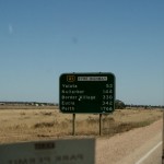
- Nearly there 🙂
-

- Lets hope we see some live ones, only dead ones we’ve seen so far apart from the camels
-

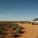
- Here we are
-
- Nullarbor roadhouse
-
- The best possie in the park 🙂
15th March, Sunday – Nullarbor Roadhouse
The road trains go all night here but it doesn’t worry us, the wind howls through the camp site and we can’t put our awning up as we think that it will blow away. A few people have pulled in as an overnighter and we are now the only ones left. Our van looks like a dunny in the desert. The morning was cool and quite refreshing so we thought we would do the sights early as it’s going to be a hot day. Our first stop is the “Head of the Bight” and this basically where it starts. The sheers cliffs stretch as far as 800kms West, so you can imagine that it’s quite a huge coastline. The Head of the Bight is a good whale viewing area when the whales are migrating, they are not here at the mo and we probably will come back in season. It’s a beautiful spot and the outlook is magnificent, this is only the start of it so I think that we are in for a big treat. We took a drive into the Nullarbor plains as there are some caves there that we wanted to see. The going is slow as the track is quite worn and rugged. You would’t want to go off the track here as there are no landmarks and everything is so flat. We didn’t see any Dingos (heard them though), snakes, wombats, roos, emus, camels, people, cars in fact ZILCH, it was awesome although we wouldn’t have minded seeing some animals. Most people drive through here and it’s a shame they don’t stop as there really is quite a bit to see. The caves are amazing, big holes in the ground, you can see the openings but it’s hard to get down there and I don’t think that we are really supposed to anyway because it’s dangerous and they have cultural significance. Two of the caves have some Aboriginal red hand prints on the walls. It’s really worth the slow rugged drive to see them, there are 3 in all, the caves are called “ Murrawijinie” – which means “Blood hands” – symbolic of the red hand prints that have been found in the caves” . The caves are named in number sequence – “Murrawijinie No.1 cave, no. 2 cave and no. 3 cave. They go quite deep and a fair way in. On the way back we found one small half dead tree on the plain so we have decided to change the name “Nullarbor” to “Unarbor”. Ralph is trying to get the sat dish working because he wants to watch the grand prix but he’s finding it a bit of a mission as it’s very windy, there is a pub here at the roadhouse so perhaps he can watch it there if they have TV. We found loads of loads of baby spiders in the van, adverse as we are to killing spiders we let loose with the Mortein, I think that the eggs must have been laid on the curtains. The nullarbor has a links golf course and the first hole starts starts in Kalgoorlie, there is a hole in various places from Kal to Ceduna. The idea is to play one hole in each place, there is one here which is called the “Dingos Den”. It’s the worlds longest golf course and you can get a score card and play the whole course if you feel up to travelling from Kal to Ceduna, it looks like fun though. I found a bit of history about how the Nullarbor roadhouse started:-
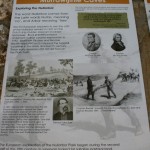
“In 1947 Coral and Elwyn Beattie moved from Penong to Nullarbor Station as station hands and life was very tough. They built an extension onto the existing timber and iron building, using stone and cement, old dingo traps and pieces of scrap iron to reinforce and strengthen it.In 1954 they were appointed managers of the Nullarbor Station. Shortly after they decided to set up a shop and sell petrol, food and water. The petrol came in 44-gallon drums, transported from Fowlers Bay. The petrol was hand pumped into a gallon measure then poured into vehicles. They also sold tinned food, cigarettes, biscuits, lollies and crystal cordial drinks.The Beatties left Nullarbor in 1960 after starting the ongoing business of Nullarbor Roadhouse, which of course continues today.”
Tomorrow we leave for Eucla and will cross the border into WA (Home turf, are we there yet?).
-
- Nullarbor roadhouse
-

- Nullarbor roadhouse
-
- Nullarbor roadhouse
-
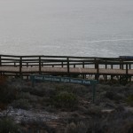
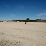
- Head of the Bight
-

- Head of the Bight
-

- Head of the Bight
-

- Head of the Bight
-
- Head of the Bight
-

- Head of the Bight
-

- Head of the Bight
-
- Head of the Bight
-

- Head of the Bight
-

- Head of the Bight
-

- Head of the Bight
-
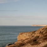
- Head of the Bight
-

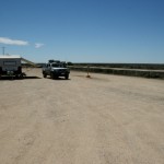
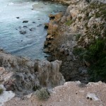
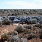
- On the way to Murrawijinie caves
-

- On the way to Murrawijinie caves
-

- On the way to Murrawijinie caves
-
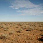
- The Nullarbor in all it’s beauty and I mean it
-
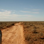
- On the way to Murrawijinie caves
-

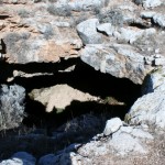
- Murrawijinie No.1 cave
-
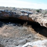
- Murrawijinie No.1 cave
-
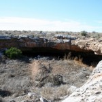
- Murrawijinie No.1 cave
-
- Murrawijinie No.1 cave
-

- Murrawijinie No.1 cave
-

- Murrawijinie No.2 cave
-

- Murrawijinie No.3 cave
-
- Murrawijinie No.2 cave
-
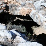
- Murrawijinie No.2 cave
-
- Murrawijinie No.2 cave
-
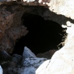
- Murrawijinie No.2 cave
-
- Murrawijinie No.3 cave
-

- Murrawijinie No.3 cave
-
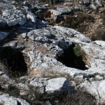
- Murrawijinie No.3 cave – the holes in the top of the rock let the sun down into the cave
-

- Murrawijinie No.3 cave- the holes in the top of the rock let the sun down into the cave
-
- Murrawijinie No.3 cave – the holes in the top of the rock let the sun down into the cave
-
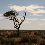
- We found a tree 🙂
-

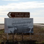
- Nullarbor Roadhouse tee off
-

- Dingos Den green – Nullarbor Roadhouse
-

- Sunset at Nullabor Roadhouse
We had a personal insect repellent called “Off” on Fraser. That worked better than the Bushmans Tropical for the March Flies. They don’t seem to like this one! You may be able to get that at the roadhouse shop!
Nice caravan park!! Safe travels! xx
Thanks, will check it out x